
Any groundbreaking programme, let alone one the scale of Mini Holland/Enjoy Waltham Forest delivered in such a short time period, will inevitably have a number of on the ground issues which need to be remedied.
Waltham Forest Cycling Campaign aims to maintain a list of known issues it believes need to be fixed, ordered by area. The council has reviewed many of these items, and a summary of their response is in red italic text.
We have categorised items as one of
- [MHD]: Mini Holland Design, high level issues (where there are repeated instances of design improvements needed) and strategic network level omissions
- [MHS]: Mini Holland Snagging – implementation detail issues, or
- [Legacy]: Issues identified to infrastructure delivered prior to the Mini Holland rollout (ie pre 2015).
- [Opportunity] Potential for new intervention to tackle long standing issues (mainly for areas which have had little active travel interventions to date)
If you know of issues affecting cyclist safety (especially those associated with new Mini Holland infrastructure), please email us at contact@wfcycling.org.uk or add a comment at the bottom of this page and we’ll investigate.
Lloyd Park & Higham Hill
(bounded by North Circular, Fulbourne Rd, Forest Rd, Lea Valley)
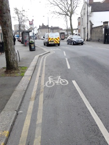
- 10 Nov 2017: Signalisation required for Billet Road/Higham Hill Rd junction. [Legacy] WFCC note: Items 1-6 are for a LIP funded scheme (not Mini Holland). This was upgraded at WFCC’s request from the original proposal for painted lines to stepped tracks along Billet Road & Blackhorse Lane. There were insufficient funds to provide continuous protection, so it was agreed with WFCC at the outset that officers seek further funding at a later date to tackle the gaps.
- 10 Nov 2017: In Billet Road the Millfield Ave/Folly Lane roundabout needs some form of protected crossing, or alternatively removal of the roundabout and return to side road status. See note for 6 above. [MHS] Still present Nov. 2023
- 10 Nov 2017: Billet Road, east of Millfield Ave. Tree pits take over half of westbound track – there is scope for realigning track to the other side of trees. See note for 6 above. [MHS] Still present Nov. 2023
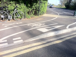
- 13 April 2017: Blackhorse Lane has a short section between St Andrew’s Road and Blackhorse Studios (between approx 116-143 Blackhorse Lane) which has a length of residential parking bays and no cycle track in either direction. The gap in the otherwise excellent protected cycling provision recently added (right up to the Crooked Billet roundabout) acts as a deterrent to the many local people who would choose to travel by cycle if there was a route with continuous high quality protection through the area. Given the huge volume of new residential units being constructed in the area, we believe this merits high priority attention. [Legacy] Still present Nov. 2023
- 13 April 2017: There’s a gap in the high quality protected cycle route on Blackhorse Lane between Hookers Lane/Blenheim Road and Forest Road. If road width is insufficient for with flow cycle tracks in each direction, we propose either a northbound or southbound track along Blackhorse Lane (a southbound track might work better as it would link up with the Blackhorse Road southbound track), and the opposing flow routed via Blenheim Road to link up with the Pretoria Avenue route. [Legacy] Still present Nov. 2023
- 12 Mar 2020: Missing eastbound track in Billet Road from Folly Lane junction for 100m. [Legacy] Still present Nov. 2023
- 19/1/17: At the entrance to the fisheries on Forest Rd, every day from 7.30am until the gates open at 8am up to 8 cars and vans are parked up which completely block the cycle way and pavement as they are waiting for the gates to the fisheries to open. Cycles are then forced onto main carriageway, which is now considerably narrower than it was. https://www.google.co.uk/maps/@51.5865468,-0.0523401,114m/data=!3m1!1e3. [MHS] Feb 2017: This is currently with enforcement team to progress. 1/2/21: WFCC update: we are not aware of recent instances and thus believe this issue has been resolved.
- 10 June 2017: The arrangement of the carriageway and bollards at the end of Grove Park Avenue at the start of the cycle track under the Billet Roundabout needs to be improved as vehicles regularly park in, or block access to, the cycle track. This request was part of WFCC’s response to the Chingford Town Centre consultation in 2016 – we’ve added it here to ensure it does not get forgotten as we are continuing to receive complaints about obstruction of the track. [MHS] 1/2/21: WFCC update: we are not aware of recent instances of obstruction and thus believe this issue has been resolved.
- 11 Sep 2017: Kerb line runs across track at both Ferry Boat Inn entrances, leading to confusing visual message on who has priority. Needs to be amended to standard kerb line treatment. [MHS] WFCC update: same issue for Wetlands entrance opposite. 4/11/23: WFCC Update: Elephant feet present in both places. Now much clearer. Nov 2023: Issue resolved.
- 13 Nov 2017: Requesting lockable bollard to prevent parents using Stoneydown Park access as a informal car park on Blackhorse Road. Drivers using the pedestrian crossing to exit this location. [MHS] Dec 2019: Issue resolved.
- 17 Nov 2017: Forest Rd needs protected east and west bound track in vicinity of Century Rd. [MHS] Still present Nov. 2023
- 18 Dec 2018: Wetlands entrance by Lockwood Way. Dropped kerb opposite required for southbound cycles. Nov 2023: Issue resolved.
- 15 Jan 2018: Eastbound cycle track in Billet Rd (east of Higham Hill Rd junction) requires the removal of lamp columns by UK Power. [MHS] Dec 2019: Issue resolved.
- Dec 2019: Reinstate give way at Century Road and Queen Elizabeth Roads to protect contraflow westbound cycles. [MHS] Markings now on road – should there be sign? Nov 2023.
- Cycle track on North Circular has no dropped kerb at the point it joins Folly Lane (just north of the roundabout – see map). Particularly dangerous as cyclists have to dismount in the carriageway on a a blind bend. [Legacy] Update June 2019: WFCC understands that this slip road is TfL managed highway and they have concerns that a dropped kerb could lead to casualties (due to poor sightlines) if cycles exited at speed onto the carriageway. However we believe that the carriageway could be amended in such a way that these issues could be overcome. WFCC is developing a proposed design. Still present Nov. 2023
- Cycle gaps in the modal filter gate in Brookscroft Road (at its junction with Sturge Avenue) are too narrow for bikes with wider handlebars, and completely inaccessible for trikes and larger cargo bikes.[Legacy] Feb 2017: May be looked at as part of Leyton – Chingford route. Still present Nov. 2023
- The Chatham Road/Queen Elizabeth Road E17 junction needs a redesign to reflect the needs of westbound cycle traffic. Currently people on bikes experience conflict with motor vehicles traveling north along Chatham Road or west along Queen Elizabeth Road. [Legacy] Feb 2017: LBWF acknowledge issues and aspirations in this area but its not currently part of MH funded programme. Aspiration to look at in next 3 years. Still present Nov. 2023
- Motorists often cut the corner of the Winns Terrace/Winns Avenue E17 junction to the extent that they meet oncoming contraflow cyclists. Physical measures such as armadillos or a traffic island is required in order to keep motor vehicles on the left half of the road and also to reduce their speed. A traffic island would also benefit people on foot crossing to Lloyd Park. [Legacy] WFCC Jan 2019: Island is being installed. Issue resolved.
- 13 April 2017: At around 0.8m the bollard gaps for the shared use path between Brettenham Avenue & Brettenham Rd are too small for many cargo bikes, bike trailers & all ability bicycles. [Legacy] Still present Nov. 2023
- 25 April 2019: Cycle contraflow required in Dudley Road for cycle journeys between Town Hall & Lloyd Park bypassing Forest Rd & Bell Corner. [Legacy] WFCC: Now a filtered area, so contraflow present. Council are considering adding a Tiger crossing. Nov 2023: Issue resolved
- 1/2/21: Farnam Avenue/Chingford Road : legacy filter bollard spacing and track width insufficient to accommodate cargo or all-ability bikes. [Legacy] Still present Nov. 2023
- 1/2/21:Billet Roundabout underpass : legacy filter bollard spacing and track width insufficient to accommodate cargo or all-ability bikes. [Legacy] Still present Nov. 2023
- 1/2/21:The route south of and parallel to the N. Circular between Chingford Road & Garner Road: legacy filter bollard spacing and track width insufficient to accommodate cargo or all-ability bikes. [Legacy] Still present Nov. 2023
- 1/2/21: Priors Croft/Priory Court: : legacy filter bollard spacing and track width insufficient to accommodate cargo or all-ability bikes. [Legacy] Still present Nov. 2023
- 1/2/21: Blackhorse Lane exit from cycle track (just south of Sopwith Ave) hazardous & unclear due to zebra & belisha beacon pole obstruction. [MHS] Still present Nov. 2023
- 26/11/23: Ramp on Thornbury Way coming south into Billet Road too steep for bikes starting at lights. Can get “trapped” in gutter, if traffic coming the other way goes too fast.
Upper Walthamstow
(bounded by Wood St, Hale End Road, North Circular, LB Redbridge border, Snaresbrook Road, Lea Bridge Rd)
- 13/2/17: East end of Buck Walk (which has recently been upgraded to shared use) needs a dropped kerb at the eastern end where it meets the carriageway. [MHS] WFCC update Jun 2017: Issue resolved as part of the redesign with filtering of Roland Rd and upgrade of zebra to parallel crossing.
- 16/6/20: Hale End Road: Remove pinch point traffic islands and replace with zebra crossings, add frequent s-humps. [Opportunity]
- 1/2/21: Woodford New Road cycle track floods after rain. Location : 51.5889739, 0.0076121, to the north of 20 Woodford New Rd. [MHS]
Hoe Wood (bounded by Hoe St, Forest Rd, Wood St, Lea Bridge Rd)
- June 2014: A
 dvisory cycle lane near 215 Wood St is pinched by combination of bus boarder pavement buildout and left hand bend, resulting in cyclists being pushed out into carriageway at the point motor traffic cuts the corner and overrruns the lane – delivering almost guaranteed conflict between motor traffic & cyclists. [Legacy] Still there Aug 2022
- Nov 2016: Walthamstow Village filtering – there is substantial rat running via Church Lane/Vestry Road, Shernhall St/Grove Road/Merton Rd & Fraser Rd, and 10pm- 10am along Orford Road/Beulah Rd/Addison Rd which causes safety issues for people on foot and bicycles at a number of locations along the route. [MHD] Feb 2017: This is being considered as part of Walthamstow Village review. Still present Nov. 2023
- Nov 2016: Some people in cars traveling too fast for conditions in Orford Road timed filter section, leading to risk of injury to those on foot/bikes. [MHD] Feb 2017: This is being considered as part of Walthamstow Village review. Still present Nov. 2023
- November 2016: Works in Shernhall St have narrowed the carriageway and created new pinch points, which has made the road less attractive for cycling, eg zebra pavement build outs at the bottom of The Drive, loss of central island protecting southbound right turn into Church Lane. The Shernhall/Drive zebra build out pinches cyclists forcing them into the traffic stream. Currently the only safe crossing of Forest Rd for over a mile is at the Shernhall St junction. How did this design get past any cycle audit process? [MHD] Feb 2017: This scheme was LIP funded and aimed to address cycling issues associated with collisions, high vehicle speeds & poor pedestrian priority, inadequate footway widths, and pedestrians being trapped at refuges between traffic streams. The specific locations raised by WFCC will be assessed as part of the Walthamstow Village review. Still present Nov. 2023
- November 2016 : There are no safe crossing points of Shernhall St for cyclists – we propose as a minimum the removal of the roundabout at the Raglan Road junction. A better option would protected facilities closer to the middle of Shernhall St, or a cycle track between Addison Rd and Oliver Rd. [MHD] Feb 2017: Desire lines & routes for cycle movements were assessed, but it was not possible to identify and design a solution for a dedicated cycle crossing in Shernhall St. Still present Nov. 2023
- 16 January 2017: Church Path is being used by some people on bikes, which it is clearly far too narrow for shared use. We recommend that changes are made to Vestry Road to permit contraflow cycling, and in addition to no cycling signs at both ends of Church Path, temporary display boards are put up signposting this alternative route. It may be worth exploring barriers on the path to further dissuade cycle use although this should be done in such a way that it does not deter use by people with mobility issues, push chairs etc. [MHD] Feb 2017: Officers don’t consider Vestry Road is currently suitable for 2 way cycling, and are currently working with local people and councillors on pedestrian priority signage as the recent cycling in parks programme. 2019: WFCC Update: Cyclists dismount signs have been erected at both ends of the path. Unchanged Nov 2023
- In particular motor traffic exiting Vestry Road into East Avenue may fail to give way to cycles traveling south along East Avenue. [MHS] Feb 2017: This is being considered as part of Walthamstow Village review. Still present Nov. 2023
- Motor vehicles turning right from East Avenue onto Orford Rd often speeds up as they approach and negotiate the junction due to the absence of motor traffic traveling into the filtered section of Orford Road. This represents a substantial safety issue for cyclists & pedestrians traveling across this junction. [MHS] Feb 2017: This is being considered as part of Walthamstow Village review. Still present Nov. 2023
- Hoe St southbound track exit into main carriageway leads to cyclists being pinched by motorists. [MHS] Note: this section was implemented early using ‘section 106’ funding, and should be resolved as part of Mini Holland project for Hoe St. Feb 2017: Will be reviewed as part of the Hoe St section design.
- Cycle route through St Mary’s churchyard into Orford Rd should permit contraflow cycling along one way section. [MHS] Feb 2017: No satisfactory resolution has been found with the church, and this is currently unlikely to be progressed. 1/2/21: WFCC update: irrespective of access past the church, permitting two way cycling along the upper part of Orford Rd would allow cycles to legally turn left from Church Lane westbound into Orford Rd. Still present Nov. 2023
- Added 14/10/16: The status of the cycle route running past St Mary’s Church needs to be formalised. TfL’s cycle map shows a short section outside the front of the building marked indicating cyclists should dismount. [MHS] Feb 2017: As per above we are having problems resolving matters here and no imminent solution looks viable. WFCC update Nov 2019: “Cyclists dismount” signage has now been added. Still problematic Nov 2023
- Timed filtered section of Orford Rd has arrows painted on carriageway indicating one way eastbound flow, yet contraflow cycling is permitted. [MHS] Feb 2017: The council can only enforce signage combination that includes a one way sign, and road markings need to reflect this. This is being reviewed. Still present Nov. 2023
- The current signage at the start of the Orford Rd filtered section means no vehicles; the ‘flying motorcycle’ version should be used which means no motor vehicles, thus permitting cycles to use it. Feb 2017: [MHS] The signage has been amended as per WFCC’s suggestion. Item Closed.
- A number of one way streets in Walthamstow Village and elsewhere (where cycle contraflows have been added) require the standard blue background one way plus contraflow signage at the start of the one way section. Eg Second Avenue, Beulah Road, Maynard Road. [MHS] Feb 2017: Walthamstow Village contraflows will be picked up as part of the review. Let council officers know of any other outside this area.
- Added 24/11/16: Shernhall St between Eastern Rd & Lea Bridge Rd still has speed cushions. WFCC had understood that all speed cushions in ‘villagisation’ areas would be replaced with sinusoidal humps. [MHS] Feb 2017: Will be looked at as part of the Walthamstow Village Review. Still present Nov. 2023
- Added 22/12/16: Milton Rd needs a westbound cycle contraflow to complete the new link via The Drive/Howard Rd/Aubrey Rd/Hoe St. [MHS] 2017: Will see whether can be included in current Hoe Wood scheme. Jun 2018: Contraflow is being progressed. Nov 2023: contraflow present. Resolved.
- Added 27/12/16: Cycle contraflow required in Wyatt Lane. [MHS] Feb 2017: Will see where this can be included in future programme. – Wyatt Lane now filtered. No Contraflow needed. Nov. 2023: Resolved
- Added 29/12/16: We believe that the Hoe/Wood measures were to include a cycle no entry bypass & contraflow for the Wood St end of Havant Road, which will provide a quiet link into Turner Road and Church Hill Rd, to Walthamstow Village or Poets Corner. [MHS] Feb 2017: Design has been developed for Havant Rd but LBWF currently in process of reviewing expenditure to date against budget to assess whether further works are possible. – Havant now filtered. Nov. 2023: Resolved
- 16 Feb 2017: Cycles locked at two sets of cycle stands at the Wingfield/East Avenue/Orford Rd are being damaged by vehicles overrunning onto the flush footway. In last 6 months we are aware of one bike completely written off, and 2 getting buckled wheels. Some form of physical protection is needed. This has also been raised as a generic design issue. [MHS] Wingfield corner now OK, East Avenue still a problem. Nov. 2023
- Hoe St/Church Hill junction is unsafe for use by people on bikes, especially if turning right from Hoe St into Church Hill, or exiting High St into Church Hill. Mini Holland is expected to deliver a better solution. [Legacy] Feb 2017: Junction will be looked at as part of MH programme but likely that there will be some limitations given proximity to Gyratory, SRN, and improvements made relatively recently. Still present Nov. 2023
- 1/2/21: Double yellow lines for Grove Rd filter at Eden Rd junction so obstructive parking can be enforced. [MHS] Double yellow line on Eden Road side, still needed past filter. Nov. 2023
Markhouse
(bounded by Hoe St, Lea Bridge Rd, Markhouse Rd, Selbourne Rd, South Grove)
- 11 July 2017: At some side road T-junctions where there is a stepped cycle track, there is no dropped kerb on the track opposite the side road; this prevents direct cycle movements between the side road and opposite track. Examples of this can currently be found on Markhouse Road. [MHD] Mar 2018 WFCC advised by officers that this design is intentional due to safety issues, and that cycles should proceeed to next formal crossing and do a u-turn. However following a review, installation has been approved for a dropped kerb opposite Markhouse Avenue.
- Edinburgh Road cycle gap too narrow – should be resolved as part of Markhouse Villagisation. [Legacy] WFCC Sep 2018: Completely redesigned with lovely pocket park. Issue resolved.
- 23/4/20: On-street cycle parking using footway buildout at the side of the Hornbeam Centre (to supplement plantlocks which have been extensively damaged by motor vehicles) has not materialised as planned, despite the e-charging bays having been completed. We furthermore suggest the car club bay is moved elsewhere to allow the single e-charging bay to be upgraded to 2 bays as the current single bay is heavily used. 23/4/20: WFC: Scheme only half implemented due to lead officer departure. [MHS]
Blackhorse
(bounded by Forest Rd, Hoe St, Selbourne Rd/Cranbrook Mews, St James St/Blackhorse Road)
- Nov 2016: Blackhorse Road – 3 bus stops (2 near the tube station, plus one around 500m south). Designed as a ‘bus boarder‘ with track running next to carriageway edge, hence bus disgorges passengers straight onto track – causes conflict due to pedestrians waiting on track, and stepping off bus into cyclists’ path. [MHD] Feb 2017: Officers agree with the potential for conflict but there is currently insufficient space for a bus stop bypass or island. TfL is using the northbound stop near the tube station as a case study in its infrastructure monitoring programme, and feedback is expected soon. Officers will review the northbound stop as part of the signalled junction redesign. Still present Nov. 2023
- Nov 2016: Selborne Road Protected cycle track A. stops 30m west of cycle hub/Walthamstow Central station. B. Does not have protected connection to Hoe St. C. Is substandard width for 2 way flow. D. Lack of footway west of bus stop on this side of the road results in high pedestrian flows. [Legacy] Feb 2017: This scheme was funded from TfL Air Quality budget and had to contain certain design elements which constrained how space was allocated. There is limited scope to make changes until the Hoe St gyratory changes are developed further. Worse, if anything – Nov. 2023
- Nov 2016: There’s no high quality northbound cycle route to complement Blackhorse Rd southbound track. [MHD] Feb 2017: Quiet route options will be considered via Pretoria Avenue & Edwards Road. Still present Nov. 2023
- December 2016: The new modal filters on the Network Rail bridges in Blackhorse Village are substandard in width; the LCDS specifies minimum width of 1.5m. Additionally as there is only one cycle gap, none of the 4 filters cater for 2 cycles traveling in opposite directions to pass at the same time. Current gap widths: Stoneydown Ave 1.28m, Richlings Ave 1.29m, Suffold Park Rd 1.3m. Pretoria Ave width is 1.5m, but the effective width is considerably less as one side is a full height post with the risk of handle bar strikes. The Pretoria Avenue filter is the highest priority for redesign as it is a key north/south route and the first to become a substantial cycle flow bottleneck. [MHD] Feb 2017: There are considerable site constraints to full width gaps, but officers will review the Pretoria Ave filter by Spring 2017. Still present Nov. 2023 – particularly bad at Pretoria.
- Blackhorse Rd track southbound, and Hoe St tracks between Granville Rd & Grove Rd – 25mm upstand between track and footway may lead to cyclists losing control and falling due to the ‘tramline’ effect. Needs 45 degree chamfered edge as per Ruckholt Rd design near to cycling zebra. [MHS] Feb 2017: There is some, but limited, funding for reviewing constructed scheme element, but this will need to be part of a prioritisation process.
- Blackhorse Rd – uneven track due to blended crossings and drainage can be difficult to use at higher cycling speeds, and requires low speed for 3 wheeled load carrying trikes. [MHS] Feb 2017: There were technical constraints associated with crossovers and utilities, but lessons have been learned. Will be included in the future prioritisation list.
- Blackhorse Rd southbound – track needs south pointing arrows as it is being used by northbound cyclists. [MHS] Feb 2017: Arrows can be added if this continues to be a significant issue.
- Blackhorse Rd track southbound – some blended crossings too wide (Northcote Road is the worst), resulting in higher vehicle speeds into side road, and less physical protection for cycles. [MHS] Feb 2017: Will be added to in the future prioritisation list.
- Following filter installation in Gaywood Rd, a resident advises vehicles are driving onto the footway to turn round. [MHS] Feb 2017: This may well be the case in Gaywood Road. The carriageway in Gaywood Road is less than 7 metres wide and some people will find this difficult to turn a vehicle around in. Where roads are filtered we endeavour to provide space to turn an average vehicle but clearly on narrow roads this becomes difficult. Nov. 2023 – At the top end, near Hoe Street, there is an old drop kerb in front of a wall. This will be tempting for owners of large cars. It could be removed. (See Google Street View.)
- 24 May 2016: A number of people on bikes have mentioned feeling uncomfortable on the Elmsdale Road contraflow – we recommend that signage is improved where vehicles enter from Erskine Road. [MHS] Feb 2017: Noted and acknowledged – some contraflow signage is still outstanding in Blackhorse Village and once Northcote goes in this will be progressed along with a review of signage at any problematic locations. WFCC update Sep 2018. Contraflow signage has been installed at Palmerstone Rd junction entrance. Ideally a couple of passing places (where parking is banned) would be added for cycles or cars to wait. Nov 2023 – There are several gaps where garage entry is protected. But some aggressive drivers do cause problems.
- Added 11/10/16: Speed cushions in Mission Grove (which is now a Quietway route) need to be removed (and if necessary replaced with other speed reduction measures) due to the conflict over roadspace they create between motor vehicles and cycles. [MHS] WFC Feb 2017: These should be replaced/removed as part of Quietway scheme. WFCC Jun 2018: All cushions removed & replaced with tables or s-humps. Issue resolved.
- 19/1/17: Speed cushions in Pretoria Avenue need to be removed. [MHS] WFCC update Jun 2018: Cushions replaced with s-humps. Issue resolved.
- 24/1/17: Motor vehicles travelling from Westbury Road into Hatherley Rd not giving way to cyclists carrying straight on through the filter. [MHS] Feb 2017: Filters at junctions will lead to this behaviour as drivers will generally feel they have priority, unless filter/junction layout specifically designed to give priority to certain movements. Nov. 2023 – The road markings curve round, implying priority for those on the road. Could this be improved?
- 16 Feb 2017: Some northbound motor traffic
 along Erskine Rd turns left at the modal filter and travels the wrong way down Gainsford Road. Footway buildouts on both sides to narrow the road to one lane (which could accomodate planters) would provide a clearer visual indication to motorists that this is a one way street. This would also help assert priority for cycles travelling through the adjacent modal flter [MHS]
 - Dec 2019: Buxton Rd/Mission Grove junction: Upgrade from gate to cycle permeable filter. [MHS]
- Dec 2019: Forest Rd track widens then narrows (twixt Hervey Pk & Ritchings) – no benefit to cycles as distance too short – return space to peds if not too expensive and can retain good quality. [MHS] Nov. 2023 – This seems to have been done to avoid painting over manholes.
- Dec 2019: Forest Rd track alignment west of Hoe St jct – could redesign to run along kerb as part of Bell Corner junction works? [MHS] This has been completely redesigned. Nov. 2023: Resolved
- Dec 2019: Need “except cycles” signage for south end of Pembar Avenue E17. [MHS] Nov. 2023: Resolved
- 31 Mar 2018: St James St/Courtney Place needs a dropped kerb. We note officers concern that is this is an awkward location in terms of safety of cycles entering St James St, but believe this improvement is worthwhile. [Legacy] Still present Nov. 2023
- Northcote Rd has contraflow lane into Blackhorse Road but junction with Maude Terrace needs “no entry except cycles” signage. [MHS] 23/4/20: May be done as part of Coppermill LN. Nov. 2023: Resolved
- 10/8/20: Cycle ramps or gullies for steps to St James St station platforms. [Legacy]
- 1/2/21: DYLs at Cleveland Park Ave filter due to obstructive parking. [Legacy] Nov. 2023 – Double Yellow line still needed, both sides (according to Street View Aug 2022). Even if only between the parking spaces either side.
- 26/11/2023: Protected left turn needed into Blackhorse Road from Hawarden (continuing from Edward Road). You get cut off, without even a bike painted on the road.
- 26/11/2023: Junction of Mission Grove & Blackhorse Road dumps cyclists into a box junction with no warning to drivers.
- 26/11/2023: Signage on Ritchings/Suffolk Park junction completely confusing. There is no “Except Cycles” on No Entry, and no need for No Entry where flying motorbike used.

Coppermill
(bounded by Forest Rd, Markhouse Rd/St James St/Blackhorse Rd, Lea Bridge Rd, LB Hackney border)
- Cycle route into Lea Valley requires users to climb steps on footbridge at west end of Black Path after it crosses Argall Avenue. There is room for ramps which would also improve access for people with pushchairs, and those with disabilities. At the very least needs wheeling ramps. [MHD] Feb 2017: Response to be confirmed.
- Just after the eastbound Lea Bridge Road cycle track enters the borough from Hackney and crosses the canal, there is a high wall which prevents adequate sightlines between motor vehicles exiting the entrance to the new residential development at Essex Wharf and the cycle track. Skid marks on the cycle track suggest its only a matter of time before there are crashes & casualties. [MHS] WFC Feb 2017: This is being reviewed and there will be a further update including the course of action. 12/6/17: WFCC understands that the developer has agreed to add louvres into the wall. Dec 019. WFCC emailed the developer several weeks ago but no response has been received.
- 12 June 2017: Essex Wharf – Kerbs run across track, leading to confusion over priority. [MHS] Still present Apr 2022
- 12 June 2017: Rubber cushion close to Coppermill Pub on Q2 should be removed. [MHS] Sinusoidal humps now used. Nov. 2023: Resolved
- 1/2/21: Double yellow lines for Hibbert Rd at filter with LBR due to obstructive parking [MHS] Still present Apr 2022
- 11 Sep 2017: Glenthorne Rd & Haroldstone Rd: Rerouting of Q2 (C26 & C27) requires the replacement of cushions with S-humps. [MHS] S-humps now present. Feb 2024: Resolved.
Leyton
(bounded by Lea Valley, Lea Bridge Rd, High Rd Leyton/Hainult Road/rail line, A12)
- Route down Marsh Lane into Lea Valley severed by bridge over rail line – has gullies for bike wheels but needs considerable strength and unusable by all ability cycles, cargo bikes, etc. [Legacy]
- Orient Way & Argall Avenue cycle track – 25mm upstand between track and footway has led to riders hitting the upstand at an angle and falling off due to the ‘tramline’ effect. Needs 45 or 30 degree “splayed” or chamfered edge. [Legacy]
- Nov 2016: Church Road to Leyton town centre link proposals do not currently offer continuous high quality solution suitable for all ability cycling, with the gyratory with Church Road of particular concern. [MHD] Feb 2017: Continuous protection is impractical due to impact on bus infrastructure and residents’ parking. More space for cycling being progressed via parking & waiting/loading changes, Long term aspiration (2017/18) remains for a continuous link, in the shorter term there will be a link via Manor Rd & Grange Park Rd.
- Nov 2016: We appreciate that junction has not been completed, but are concerned that the armadillos and removal of ASL on Ruckholt Rd westbound after the rail bridge means people on bikes are less able to take primary position when approaching lights, and are thus prone to left hooks from motorists turning into Temple Mills Lane. Also Ruckholt Rd westbound cyclists are appearing from the bridge to the junction out of the blue from drivers’ perspective. And the junction has no separation in time, so fast-moving cyclists are rocketing off the bridge into left-turning cars if the lights are green. [MHD] Feb 2017: Intention is to improve this junction when funding and resources become available. WFCC Dec 2019: Work starts shortly.
- Ruckholt Road/Carpenter Rd cycle zebra – additional speed hump might be wise to slow motor vehicles on approach to crossing due to risk of drivers not having time to react to cyclists entering zebra. This configuration is unusual due to cycles heading westwards running parallel to motor traffic before making a right turn across the zebra. [MHS] Feb 2017: Officers are not aware on any issues, but this will be considered in future.
- Ruckholt Road signal timings are fixed and do not take account of queue sizes. [MHS] (Note that the signals are due to be linked to TfL’s “SCOOT” system which should largely resolve this). Feb 2017: Signals are on SCOOT – but system has to work within parameters and when traffic volumes are large will queuing will take place.
- Ruckholt Road east bound cycle filter. Motorists sometimes proceed when cycle filter light is green, leading to risk of left hook of cyclists. [MHS] Feb 2017: Some measures have already been put in place such as louvres and cowlings to restrict motorists visibility of cycle lights, and physical changes are currently taking place to provide more separation between users. WFCC update 15/8/17: We’re getting reports of frequent violations by drivers. A suggested improvement is moving the cycle lane signals back from the junction to reduce the risk of confusion and increase the time available for cyclists to spot an incoming left hook. WFCC update 13/11/17: Engineers are investigating if louvres can be added to the cycle signals so they are not visible to motorists.
- 6 April 2016: Narrow stepped hump across the road on the bridge in Marsh Lane at Jubilee Park entrance. Would be uncomfortable to cycle over and unsuitable for cargo bikes. A strip about 50cm wide has been left at road level for cyclists however the whole design is not really suitable for a site with aspirations to have a cycle hub. [MHS] Feb 2017: We are aware of this and currently looking at schemes/funding opportunities to take this forward. WFCC 8/4/17: A second narrow hump has been added. We’re wondering if this is not public highway and thus the work is being done by the Sports & Leisure Department who are unaware of the needs of cyclists.
- 4 May 2017: Motorists are cutting the corner as they exit Vicarage Rd into Park Rd, bringing them into head-on conflict with cyclists using the Park Rd contraflow. We propose an island in Park Rd as per the photo, plus potentially cycle logos across this and other Park Rd junctions to remind road users of the presence of contraflow cycles. [MHS]
- 20 Oct 2017: Church Road/Capworth junction: Cycles squeezed on southbound approach to junction- track should run up to junction. [MHS]
- 21 Feb 2018: New car park crossover on Orient way, kerbs break visual priority of track. [MHS]
- 1 June 2018: Lea Bridge Road has left/right hook concerns for cycles on the tracks at the following junctions Heybridge Way, Rigg Approach, Lammas Rd.. [MHS] WFCC update Nov 2019: Lammas Rd junction has been substantially improved. Heybridge Way design being developed.
- Jun 2019: Orient Way crossover into Ive Farm car park – kerbline needs to be amended to reinforce visual priority. [MHS]
- Jan 20: Capworth St/Vicarage Rd junction. Cycle/car conflict for northbound cycles as cars cut the corner. [MHS] 23/4/20: WFC: Could be resolved via signing & lining, as there’s not enough space for a physical infrastructure solution similar to Whinns Avenue.
- Jan 20: Capworth St/Vicarage Rd – cycle/car conflict for northbound cycles as cars cut the corner. 23/4/20: WFC: Could be resolved via signing & lining, not enough space for Whinns type approach. [MHS]\
- 16/6/20: Traffic signals Lea Bridge Road/Markhouse Rd – drivers go on green cycle light, request for louvres on westbound cycle signal. [MHS]
- 10/8/20: Pinch points due to insufficient road width & pedestrian refuges on Church Road Leyton (east of Oliver Rd jct). [Legacy]
Forest
(bounded by Lea Bridge Road, Snaresbrook Road, LB Redbridge border, A12, rail line/Hainult Road/High Rd Leyton)
-
4 February 2017: Grove Green Rd northbound cycle track (north of the Fairlop Rd


junction) has 50m of unprotected track flush with the carriageway, presumably due to multiple crossovers. Yet on approach to the Kings wood Rd junction there is a crossover section with a far better design using a 30mm stepped kerb (see photo with keys). Here’s our preferred approach (with a slight fall towards the carriageway on the footway and track to ensure rainwater runoff):
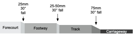
[MHD] Click here for some useful information on other options. Feb 2017: Currently being reviewed, but this section is unlikely to be redone. Once double yellow lines are in drivers are much less likely to cross onto the track (compared to advisory lanes).
- 19/10/16: Cyclists performing a right turn out of Kingswood Rd into Gainsbrough Rd can get a wheel stuck in the bridge expansion joint (this happened recently to a cyclist who needed the assistance of a passing motorist to extract his cycle wheel). This is not a new issue, but one which should be solved as part of the MH Leyton Town Centre cycle tracks for Gainsborough Rd. [MHS] Feb 2017: Noted but unclear what solution would be. WFCC 8/4/17: Junction has been completely redesigned as part of Mini Holland funded tracks & blended crossing, meaning cycles take a different line. We will review whether this is still a substantial issue. WFCC update Jun 2018. Junction has been widened following complaints from motorists; this has resulted in a substandard solution for the northbound cycle track where it crosses the expansion joint and rises steeply plus a 75mm vertical kerb on the left of the track. Currently this can only safely be cycled at a walking pace and even at that speed is very challenging for 3 wheelers.
4/1/17: Cycle track alongside A12 needs dropped kerbs with double yellow lines to allow cycle access to/from Dyers Hall Rd, Connaught Rd & Maderia Rd. [MHS] WFC Feb 2017: To be looked at as part of Leyton/Leytonstone Town Centre schemes. WFCC update Jun 2018 Dropped kerbs added. Issue resolved.- 16/6/20: Traffic signals Lea Bridge Road/Whipps Cross Rd – drivers go on green cycle light, request for louvres on westbound cycle signal [MHS]
- 16/6/20: Snaresbrook Rd. Eastbound narrow painted lane, westbound narrow shared space. There appears to be space to work with Redbridge to deliver protexted tracks right through to Woodford Rd [Opportunity]
- 16/6/20: Upgrade Fairlop Rd/Grove Green Rd junction to all green scramble [MHS]
- 16/6/20: Upgrade Leyton Green Rd/Lea Bridge Rd to all green scramble [MHS]
Leytonstone (bounded by Harrow Rd, Cathall Rd, A12, LB Redbridge border)
 2015: The cycle track in Bush Rd at its junction with Browning Rd has a dropped kerb which is too narrow and does not span the painted track, with the consequential risk of injury for users. [Legacy] Feb 2017: Will look to pick up as part of maintenance programme.
- 1/2/21: Trinity Close/Granleigh Road filter: legacy filter bollard spacing doesn’t accommodate cargo or all-ability bikes. [Legacy]
Cathall
(bounded by Cathall Rd, Harrow Rd, LB Newham border, River Lea, A12)
- 12 Mar 2020: Holloway Road/Corn Road modal filter requires dropped kerb and double yellow lines. [Opportunity]
- 12 Mar 2020: Downsell Road/Hall Road filter lacking cycle gaps and dropped kerbs; this is on a useful backstreet route between Leytonstone High Road & High Road Leyton/Drapers Field. [Opportunity]
Highams Park
- 16/6/20: Cycle link from the bottom of Winchester Rd E4 across the A406 to Forest View Rd: Winchester Road parking in marked bays overspills to block entrance to cycle path and pavement. Needs some type of physical intervention to stop parking. [MHS]
- 10/8/20: Wadham Rd parallel crossing (near Winchester Rd/Fulbourne Rd junction) proposed improvements: remove the divider to improve motor vehicle driver compliance for people crossing, reduce the carriageway width and tighten the swept kerbs to bring speeds down. [MHS]
Chingford Mount
- December 2016: Upgraded modal filter on the Walthamstow to Chingford quiet route in Nelson Rd at its junction with Selwyn Avenue

 is substandard in width for both cycle gaps with kerbstone to gate post distance only 1.11m. [Legacy] WFC March 2017: This work was not part of the Mini Holland programme, and is a temporary filter to allow construction traffic access to works at nearby school. WFCC update March 2020: The temporary filter is still in place – we assume S106 funds were made available to restore this to a standard filter design.
- Quiet route from Crooked Billet to Chingford signage needs to be refreshed. Many of the signs have been vandalised, and the painted bike logos on the road surface have faded badly. [Legacy] Feb 2017: This is being superceded by HighamsPark/Chingford quietways and Leyton-Chingford route –full signage review currently taking place.
- 16/6/20: Pedestrian refuges create pinch points, especially dangerous on the steep hill sections due to driver impatience plus speed differential on Old Church Road, Chingford Mount. Propose these are replaced with zebra crossings. [Opportunity]
Generic design issues
- Nov 2016: Blended crossings – some crossings require bollards or other vertical marker to reduce visual width of many roads and encourage motorists to reduce speed as they enter such as trees, planters, cycle parking, bell bollards, etc. [MHD] Feb 2017: Officers have visited a number of locations with WFCC to discuss concerns, and since summer 2016 have tried to define a consistent design for low flow two-way, one-way and higher flow two-way side roads to minimise the need for additional street furniture. Where this is not possible or abuse is occurring additional street furniture is being considered. Officers are aware some village scheme crossings need further review and there is still some variation in approach between design and construction engineers.
- Nov 2016: A general design flaw we are seeing frequently is damage to cycle parking stands (and sometimes parked bikes) are on footways which are flush with the carriageway (which is raised due to a blended crossing). The most common cause is that drivers are unable to see the stands in their mirrors as they reverse into flush parking bays and overrun onto footway areas (which of course they shouldn’t be doing in the first place). We recommend either a physical bollard between flush motor vehicle parking bays and
 the stands, or a the stand nearest the parking bay has a 2m post with a cycle parking sign. [MHD] Feb 2017: New designs are being reviewed to relocate cycle parking away from obvious conflict areas or to provide better conspicuity/protection.
 - Nov 2016: The standard Mini Holland track design is pavement, then cycle track to the right, then carriageway to the right. However sometimes WFCC is seeing proposals where the footway and track are switched so pedestrians are sandwiched in between cycles and motor traffic; we accept there may be occasions when this is required for short stretches, but recommend this is not adopted unless absolutely necessary. [MHD] Feb WFC 2017: This only happens in exceptional circumstances where its the only viable option to get a cycle track in. Item closed.
- Some parking stands are placed too close to bulky street furniture such as litter bins making locking cycles more difficult. Eg outside Mamachari Bikes in Forest Rd. [MHD] Feb 2017: Greater consideration is now being given to cycle stand design/layout by our design team so this issue should not arise as part of new projects. More specifically the Forest Road cycle parking layout is being redesigned as part of the route scheme and this particular issue will be resolved.
- Some new modal filters have gaps between bollards & planters etc of less than the standard 1.5m, which may impact cargo bikes, trikes and all ability cycles. Others have gaps so wide the motor vehicles are still driving through … admittedly the motorists concerned are sometimes driving through flower beds and over kerbs, but this underlines the need for the design to include physical obstructions which are too high to drive over. Grove Road is an example of a filter where cars have driven in between the bollard and the temporary tree planter. We’d like the council to do an audit of all filters and upgrade to the agreed standard. [MHD] Feb 2017: All new designs/filters will be to the agreed minimum 1.5m design unless there are exceptional site/scheme specific issues that restrict LBWF from doing this in the first instance (e.g Pretoria Ave bridge filters). Where filters are being abused and this is being reported ad-hoc adjustments have/are being made to address these on a site by site basis. A more general review will take place at some point. Dec 2017: Grove Rd has been resolved with additional bollards.
- Cycle stand design doesn’t work well for open framed bikes, as they tend to slide & fall over – would be helped by a cross bar. [MHD] 23/4/20: Design needs to be reviewed after current stock used (about 100).

You must be logged in to post a comment.